Many of the communities located in the Pacific Ocean inhabit formations known as coral atolls which consist of a series of coral islands that partly or completely encircle a lagoon. There are over 175 coral atolls in the pacific (figure 1) however there small size is emphasized by the fact that these atolls collectively account for only 1800km2 of land area. In this post I am going to look at how Pacific atolls are formed and explore the importance of this in the face of rising sea levels due to global warming. This information is well presented in a paper by Dickinson (2009) which forms the basis of this post.
 |
| Figure 1: Map of Coral Atoll provinces highlighted in red, where atolls are too small to show to scale circles are used (source). |
At the peak of the last glacial period there was a decrease in eustatic sea level (the level of water if water from all oceans was contained in a single basin) to around 120m below the present sea level. This drop in sea level meant that carbonate atoll platforms began to rise above sea level forming emergent limestone plateaus.
In the postglacial the effect on sea level was reversed and eustatic sea level rise occurred which led to water submerging the formally emergent limestone plateaus. This overtopping of the plateaus by the ocean water allowed coral reefs to begin to grow on top of the degraded reefs from the previous interglacial which already existed upon these limestone plateaus. These reefs can grow to be incredibly thick and coring of seven coral atolls has shown that Holocene reefs have reached a thickness of 14 ±4m. The reefs take their shape not due to the way in which coral grows but due the saucer shaped surface of the limestone platforms on which they grow. The platforms form this characteristic saucer shape due to solution weathering that occurs as they sit exposed above sea level.
Due to sea level rise during the early Holocene atoll reefs grew at the same pace if not faster than the rate of sea level rise and thus were able to match low-tide levels during the mid-Holocene Pacific highstand (the point where sea level reaches its highest level). This highstand occurred as during the early Holocene eustatic sea level rise occurred as water was transferred from ice sheets to oceans. However, subsequently sea level in the Pacific decreased due to global isostatic adjustment. This process occurs as during the glacial period the huge weight of ice sheets causes the earth’s crust to be depressed displacing the fluid mantle underneath and causing it to flow away from this area of depression. However, when the weight of the ice sheets is removed the viscous mantle material flows back into this formally depressed area and the earth’s crust slowly rebounds. However, while some areas rebound, others that previously sat on the periphery of the ice sheet are now depressed under the huge weight of water that is now pushing down on top of them. When areas of the ocean floor sink it is known as hydro-isostasy and this process creates space for water to flow into. Overall this process is called ocean siphoning and it occurred in the late Holocene causing a draw down in sea level in the tropical Pacific (Dickinson, 2004). Thus we can see that rising sea level in the early Holocene and declining sea level in the late Holocene created a period in the mid-Holocene where sea level was at its highest. This process is illustrated well in figure 2, which shows how sea level in the tropical Pacific has changed throughout the Holocene.
 |
| Figure 2: A representation of the mid-Holocene highstand (source). |
As mentioned previously reef growth kept pace with low tide levels during this highstand and thus when sea level subsequently declined these reef flats sat above the water level; they now sit anywhere between 1 and 2.4m above present day low tide level. The point at which high-tide levels fell below that of the surface of the reefs is known as the cross-over date and varied between atoll clusters. Once this had occurred islets are constructed due to wave action as storm wash over covers with sediment, coral flats sitting on solid carbonate foundations. These formations are called pinned islets due to the paleoreef base that they sit upon and it is these underpinnings that act to protect the islets from destruction by wave action, thus these are the stable islets that compose atolls. Such islets are most prevalent along the windward side of atolls where coral reef growth is most vigorous due to nutrient rich sea water being constantly moved across the formation. In contrast to this, sand cays which form in low energy areas where water is more stagnant, do not have these solid underpinnings and thus are liable to shift their position even under fairly calm conditions.
So what are the consequences of atoll formation in light of sea level rise? If sea level rise occurs at a rate of 10mm/year then crossover dates, the date when rising high tides will result in submerging of mid-Holocene paleoreefs, are likely to occur in the mid to late 21st century between 2050-2080. If a more conservative rate of sea level increase of around 50mm/year occurrs then this would delay the crossover date until somewhere in the first half of the next century. After this crossover has occurred even stable pinned islands will be vulnerable to the destructive force of wave action removing the unconsolidated sediment that sits atop the reefs even under fair-weather conditions. It can thus be seen that these pinned islets are liable to destruction even before sea water completely submerges the islets.
This post has shown that there are two different ways in which islets are formed and below (figure 3) a diagram of the largest atoll of Tuvalu can be seen with the different atolls classified into these types. It has been shown that the way in which islets are constructed has a direct influence on their vulnerability to erosion. Islets that do not have a stable underpinning are much more vulnerable to wave action even under modern sea levels, compared to those with a stable paleoreef under pinning. However, it has also been shown that in the face of sea level rise due to global warming even pinned islets will become exposed to increasing erosion and this will occur before water over tops the islets. I think that the key point then is that due to the geomorphology of atolls the threat due to sea level rise is not simply that water may overtop islets but that long before this happens the effects of increased sea level on processes of erosion may have a devastating impact.
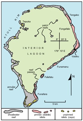 |
| Figure 3: Funafuti, the largest atoll of Tuvalu (source). |
No comments:
Post a Comment