I have found a really interesting web resource on the theme of climate change and its influence on small islands in the Pacific that I thought I would share. At www.pacificclimatefutures.net a web tool can be found which allows the user to explore the impact of climate change on fifteen different countries in the Pacific based on three different future emission scenarios. The data for this tool comes from eighteen different climate models over three different time periods, 2030, 2055 and 2090. The basic user interface available to everyone provides projected changes in annual temperature and rainfall. Without looking at the raw data an overview is provided which classifies future change into a number of groups such as “warmer and much wetter” or “warmer and drier” and provides the likelihood of each impact coming about by showing the number of climate models which predict a particular outcome.
An example of some of the read out from this website for the country of Nauru by 2030 under a medium emission scenario is shown below as well as showing the overall results for all models:
Most Likely Change Climate Future
"Warmer and Wetter to Much Wetter", represented by 12 of 18 models.
Annual mean air temperature increases of 0.9 °C and annual mean rainfall increases of 14% relative to 1981-2000
Least Change Climate Future
"Warmer and Little Change in Rainfall", represented by 3 of 18 models.
Annual mean air temperature increases of 0.8 °C and annual mean rainfall increases of 1% relative to 1981-2000
Other Potentially High Impact Climate Future
"Warmer and Much Drier", represented by 1 of 18 models. Annual mean air temperature increases of 0.6 °C and annual mean rainfall decreases of 18% relative to 1981-2000.
"Warmer and Much Wetter", represented by 6 of 18 models.
Annual mean air temperature increases of 1.1 °C and annual mean rainfall increases of 18% relative to 1981-2000.
Temperature and Rainfall changes relative 1980-1999.
This website is definitely worth looking at as it really helps breakdown the impact that future climate will have on particular countries rather than providing rather general projections provided other very large areas.
In an earlier post I introduced the problem of the drought that Tuvalu was experiencing, however I am aware that since I first mentioned it around a month ago now, I have offered little update on the situation. Therefore in this post I am going to look at what the situation in Tuvalu is like now, as well as sharing with you some very interesting geopolitical repercussions of the aid response.
In early October the government of Tuvalu declared a state of emergency as a severe drought lasting over five months left the country with a severe shortage of freshwater. As previously discussed this crisis was met with a rapid response from other countries in the region. Both New Zealand and Australia quickly transported fresh water and water containers to the area to help ease the problem. In addition desalination units were provided with the ability to produce a litre of freshwater every minute from sea water. The government of Tuvalu also acted by implementing water rationing to limit the consumption of the scarce water resources.
In late October heavy rain arrived allowing the government of Tuvalu to lift the state of emergency that had been imposed and ease the rationing of fresh water. This rain marked the start of the rainy season for the region which naturally resolves any remaining water scarcity issues. However, action was still required, and a lot of work undertaken making sure that roofs and guttering were in good condition so to effectively collect rainwater.
This situation has served to show the importance of being well prepared for similar situations that may occur in the future. To this end emphasis is being on put on raising awareness about this issue and teaching the population how to effectively maintain systems to collect rainwater. Furthermore it has also highlighted the importance of making sure people are trained in fixing Tuvalu's own desalination plants and making sure spare parts are readily available.
It is excellent news that this crisis has been resolved and I am glad to be able to share with you this positive outcome. Now, you're probably expecting this post to end now with this positive conclusion. However, on reading about the relief effort I came across a really interesting geopolitical dimension to this crisis, and feel this is so interesting it too must be shared.
During the crisis Abkhazia provided Tuvalu with a large amount of freshwater, a seemingly helpful act from one region in response to the huge need of another. However if we look at little deeper at the donor state it gets much more interesting. Abkhazia is a break-away region of Georgia which considers itself an independent state. However, this independence is not recognized by Georgia which considers the area an autonomous region of the Georgian state. In addition Abkhazia has little international recognition with only six states world wide recognizing its independence. Most notable of these states is Russia which heavily backs Abkhazia and engaged in military conflict with Georgia over the disputed area as recently as 2008.
The donation of water by Abkhazia therefore sees the conflict between Russia and Georgia being played out in the Pacific. Georgian officials claim that this act is part of a strategy by Abkhazia to help aid-dependent countries and in doing so get them to recognize Abkhazian independence. Coincidentally just one month previous to this donation of water Tuvalu officially announced its recognition of an independent state of Abkhazia. While both Russia and Abkhazia claim that the aid was a no-strings attached response to a genuine emergency, the Georgian government claim that it amounts to Russia buying recognition for Abkhazia.
In response both Australia and New Zealand have urged Russia to stop any further action in the region. They see Russian actions as taking advantage of extremely vulnerable countries with the aim of furthering their own agenda which has little at all to do with the region.
Overall we can see that the crisis in Tuvalu is now over but the aid effort contained some really interesting geopolitical elements that are sure to surprise many reading this.
A threat being posed by climate to society is by no means a new phenomenon. In this entry I will focus upon a climate event known as the ‘A.D. 1300 Event’ and the effect that it had on inhabitants of islands throughout the Pacific.
The year 1300 A.D. marks the beginning of a period of transition lasting around 200 years between a time of warm dry conditions commonly referred to as the Medieval Warm Period (MWP) and a time of cooler conditions know as the Little Ice Age. This period while also largely dry saw a substantial yet short lived increase in precipitation in many areas across the Pacific. The transition from one stage to the other saw a temperature reduction of around 1.5oC and a reduction in sea level by between 75 and 115cm. It has been shown by Nunn (2000) that such a change in climate associated with this transition fundamentally changed societies across the islands of the Pacific.
It is put forward by Nunn (2000) that the 1.5oC reduction in temperature will have led to a reduction in crop yields, particularly for those crops that before the transition were already living at the edge of their temperature tolerance, leading to a reduction in food availability. The productivity of marine ecosystems, especially those close to the shore line is also likely to have been reduced. An example of this is the reduction in pearl oysters in the Cook Islands to such an extent that they were no longer harvested after 550 cal yr BP, in addition there was as a change in fishing strategies implemented as fisherman had to sail further afield to catch fish (Nunn, 2003).
Sea level fall had similarly negative effects on marine ecosystems as the most productive parts of reefs emerged from the water. As these ecosystems were relied upon by the inhabitants of many Pacific islands for food, the reduction in resources led to the carrying capacity of islands being exceeded and thus the subsequent increase in competition resulted in conflict between different groups of humans (Nunn, 2003).
In Fiji there is evidence of the first construction of forts around 500-700 BP therefore supporting the idea that it was a change in climate that led to conflict with the islands society. A detailed study of the Lau group in eastern Fiji has shown that there was a change on the location of settlements from being located by the coast to more easily defensible hilltop locations. The size of these hilltop settlements was also much less than that of coastal settlements. The move towards a large number of small fortified settlements has been explained by a rise in internal conflict that resulted due to a depletion of marine resources. There is also evidence of a similar event occurring on a small group of islands of Micronesia called Palau. Nunn (2000) explains that in this area a catastrophic climate event around 1200AD destroyed the islands’ resource base and thus caused conflict which resulted in the areas inhabitants moving from the three large high islands that comprise Palau to more easily defended offshore rock islands.
The conflict that occurred in the pacific led to the settlement of a number of newly habitable areas. As mentioned in the previous post sea level reduction led to the emergence of new reef islands that could then be settled. In addition, sea level reduction led to a fall in the water table of many islands and therefore previously swampy areas dried out and became habitable. An example of this is the Lelcei valley of Aneityum island, Vanuatu, which was first occupied around 642 cal yr BP.
Another facet of society that was affected by the climate transition was voyaging which was brought to its end. During the MWP humans in the Pacific undertook long distance voyages as evidenced by the settling of Easter Island and New Zealand. However archaeological and oral-historical evidence shows that during the LIA contact between islands was suddenly and greatly reduced. It has been posited that this occurred due to an increase in precipitation and storminess as well as due to a loss of cultural will to undertake such journeys
.
Overall it can be seen that the change in climate that occurred around 1300 A.D. had a hugely significant impact on societies located in the Pacific. Most notable is the cultural transformation from a peaceful society where large populations lived in coastal settlements to a society where conflict was rife. As such people moved from settlements in the coastal areas of large islands to settlements located on more easily defendable, more dispersed and smaller islands. A complete model of the effects of this event can be seen in figure 1.
Figure 1: A model of the A.D '1300 event' (Source).
Many of the communities located in the Pacific Ocean inhabit formations known as coral atolls which consist of a series of coral islands that partly or completely encircle a lagoon. There are over 175 coral atolls in the pacific (figure 1) however there small size is emphasized by the fact that these atolls collectively account for only 1800km2 of land area. In this post I am going to look at how Pacific atolls are formed and explore the importance of this in the face of rising sea levels due to global warming. This information is well presented in a paper by Dickinson (2009) which forms the basis of this post.
Figure 1: Map of Coral Atoll provinces highlighted in red, where atolls are too small to show to scale circles are used (source).
At the peak of the last glacial period there was a decrease in eustatic sea level (the level of water if water from all oceans was contained in a single basin) to around 120m below the present sea level. This drop in sea level meant that carbonate atoll platforms began to rise above sea level forming emergent limestone plateaus.
In the postglacial the effect on sea level was reversed and eustatic sea level rise occurred which led to water submerging the formally emergent limestone plateaus. This overtopping of the plateaus by the ocean water allowed coral reefs to begin to grow on top of the degraded reefs from the previous interglacial which already existed upon these limestone plateaus. These reefs can grow to be incredibly thick and coring of seven coral atolls has shown that Holocene reefs have reached a thickness of 14 ±4m. The reefs take their shape not due to the way in which coral grows but due the saucer shaped surface of the limestone platforms on which they grow. The platforms form this characteristic saucer shape due to solution weathering that occurs as they sit exposed above sea level.
Due to sea level rise during the early Holocene atoll reefs grew at the same pace if not faster than the rate of sea level rise and thus were able to match low-tide levels during the mid-Holocene Pacific highstand (the point where sea level reaches its highest level). This highstand occurred as during the early Holocene eustatic sea level rise occurred as water was transferred from ice sheets to oceans. However, subsequently sea level in the Pacific decreased due to global isostatic adjustment. This process occurs as during the glacial period the huge weight of ice sheets causes the earth’s crust to be depressed displacing the fluid mantle underneath and causing it to flow away from this area of depression. However, when the weight of the ice sheets is removed the viscous mantle material flows back into this formally depressed area and the earth’s crust slowly rebounds. However, while some areas rebound, others that previously sat on the periphery of the ice sheet are now depressed under the huge weight of water that is now pushing down on top of them. When areas of the ocean floor sink it is known as hydro-isostasy and this process creates space for water to flow into. Overall this process is called ocean siphoning and it occurred in the late Holocene causing a draw down in sea level in the tropical Pacific (Dickinson, 2004). Thus we can see that rising sea level in the early Holocene and declining sea level in the late Holocene created a period in the mid-Holocene where sea level was at its highest. This process is illustrated well in figure 2, which shows how sea level in the tropical Pacific has changed throughout the Holocene.
Figure 2: A representation of the mid-Holocene highstand (source).
As mentioned previously reef growth kept pace with low tide levels during this highstand and thus when sea level subsequently declined these reef flats sat above the water level; they now sit anywhere between 1 and 2.4m above present day low tide level. The point at which high-tide levels fell below that of the surface of the reefs is known as the cross-over date and varied between atoll clusters. Once this had occurred islets are constructed due to wave action as storm wash over covers with sediment, coral flats sitting on solid carbonate foundations. These formations are called pinned islets due to the paleoreef base that they sit upon and it is these underpinnings that act to protect the islets from destruction by wave action, thus these are the stable islets that compose atolls. Such islets are most prevalent along the windward side of atolls where coral reef growth is most vigorous due to nutrient rich sea water being constantly moved across the formation. In contrast to this, sand cays which form in low energy areas where water is more stagnant, do not have these solid underpinnings and thus are liable to shift their position even under fairly calm conditions.
So what are the consequences of atoll formation in light of sea level rise? If sea level rise occurs at a rate of 10mm/year then crossover dates, the date when rising high tides will result in submerging of mid-Holocene paleoreefs, are likely to occur in the mid to late 21st century between 2050-2080. If a more conservative rate of sea level increase of around 50mm/year occurrs then this would delay the crossover date until somewhere in the first half of the next century. After this crossover has occurred even stable pinned islands will be vulnerable to the destructive force of wave action removing the unconsolidated sediment that sits atop the reefs even under fair-weather conditions. It can thus be seen that these pinned islets are liable to destruction even before sea water completely submerges the islets.
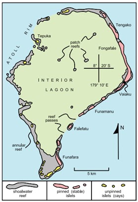
This post has shown that there are two different ways in which islets are formed and below (figure 3) a diagram of the largest atoll of Tuvalu can be seen with the different atolls classified into these types. It has been shown that the way in which islets are constructed has a direct influence on their vulnerability to erosion. Islets that do not have a stable underpinning are much more vulnerable to wave action even under modern sea levels, compared to those with a stable paleoreef under pinning. However, it has also been shown that in the face of sea level rise due to global warming even pinned islets will become exposed to increasing erosion and this will occur before water over tops the islets. I think that the key point then is that due to the geomorphology of atolls the threat due to sea level rise is not simply that water may overtop islets but that long before this happens the effects of increased sea level on processes of erosion may have a devastating impact.
Figure 3: Funafuti, the largest atoll of Tuvalu (source).
In the true spirit of my last post I felt that I should look at some of the adaptation strategies being implemented on Tuvalu so to combat climate change. Although here the focus is on Tuvalu the general principal of the strategies discussed holds for all small islands at risk due to climate change, and thus may be implemented wherever a threat exists.
A particularly interesting document I have found is Tuvalu's national adaptation action plan which highlights seven key project areas each dealing with an 'urgent and immediate' threat due to climate change.
Project 1 - Increasing resilience of Coastal Areas and Community Settlement to climate change.
The problem of coastal erosion is being dealt with through a number of methods. Coastal currents which directly impact erosion are particularly strong between islets and as such concrete barriers are being constructed to act as breaks to reduce the strength of these currents and thus reduce coastal erosion. Coastal defences such as sea walls are being constructed in some areas to combat erosion and reduce saltwater intrusion. Such projects have had varying degrees of success in different locations. In addition to these large scale construction projects community based afforestation is being encouraged by programmes such as the 'adopt-a-tree' programme which aims to create protective bands of trees along windward coasts so to help stabilise coasts.
Project 2 - Increasing Pulaka Productivity.
Pulaka is a salt intolerant plant and as such seawater intrusion is leading to these plants rotting in the ground. This has raised particular concerns for very poor families as they will not be able to afford the imported goods that the community will have to rely on for food. To prevent this from happening salt tolerant Pulaka species are being introduced. Along with introducing this new species, local farmers are being trained how to plant and maintain these plants. This new species is being promoted as a locally sourced alternative to rice, and local people are being taught how to cook it in the hope that food security will be ensured.
Project 3 - Adaptation to frequent water shortages.
Rainwater is relied upon as a source of freshwater by the people of Tuvalu due to saltwater intrusion into the freshwater lens; as such, to guard against vulnerability to draught it is important to increase household freshwater storage capacity. This is being done by distributing rainwater tanks to store water in as well as installing guttering so to channel water into these tanks.
The second focus of this project is that of water conservation. This part of the project aims to raise public awareness of the importance of water conservation, teaching people how they can use water in a more efficient manner as well as helping install water conservation technologies. These technologies help reduce the amount of water output into streams and therefore reduce groundwater pollution.
This part of the project has become increasingly important in recent months and efforts have been stepped up to enhance water security for the people of Tuvalu. One solution to the recent drought has been to deploy a mobile water treatment system which can produce drinking water from almost any raw water source and is at present doing so at a rate of around 40,000 litres a day.
It is essential to increase the Tuvaluan people's capacity to fight climate sensitive diseases that will, with increasingly warm temperatures, become more likely to spread throughout the population. Community resilience is being built up through the development of a 'vector outbreak control plan' as well through the spraying of areas which are most suitable to being vector breeding grounds. Increasing availability of freshwater in the ways previously mentioned alongside the building of 'community sanitary aides’ will help enhance the islands sanitary conditions and thus help reduce the contraction and spread of climate sensitive diseases. Awareness of diseases is also being raised through education of children in schools as well as through the production of radio programmes and leaflets which help to inform the general public.
Project 5 – Strengthening of community based conservation programmes.
Many coastal marine resources are at risk of damage and destruction due to rising sea surface temperatures. This problem is made worse by coastal erosion, which further degrades delicate ecosystems such as coral reefs as eroded material is deposited upon them. To protect vulnerable coastal environments a community-based sustainable management plan for the islands is being developed. This will include taking stock of the existing marine resources and identifying the area’s most vulnerable due to climate change. In addition public awareness will be raised about how to implement a wide range of conservation practices and the importance of doing so illustrated. In doing so it is hoped that in the long term marine environments will be protected, thus marine biodiversity will be maintained and the community’s income from marine resources will be secured.
Project 6 - Strengthening of Community Disaster preparedness and response capability.
Due to climate change the incidents of natural disasters in Tuvalu have increased, therefore it is highly important that local people are prepared to cope with such events so to reduce any casualties that may occur. To this end community awareness is being raised about the existing disaster response plan and a further disaster preparedness and response strategy is being developed. This will be accompanied by an increase in the amount of climate knowledge that is communicated to the people of Tuvalu so to increase the understanding of extreme climatic conditions may occur. In addition to being able to respond to climate hazards it is important to try and reduce the risks and economic losses associated with such hazards and as such disaster risk reduction training is being undertaken.
Climate monitoring and early warning systems are also being developed so to increase the amount of information about weather systems in the area and further enhance the speed of response to climate hazards.
Project 7 – Adaptation to coastal shellfish fisheries resources productivity.
Many shellfish in the coastal waters of Tuvalu are already living in the upper end of their temperature tolerance and therefore any further increase in sea surface temperature may devastate shellfish populations. Populations are further suffering due to habitat destruction and low breeding rates which are associated with climate change. It is important to act to save these resources as they are an essential source of protein for many low-income families. Therefore vulnerable shellfish populations are being moved from their current location to more suitable sites, breeding programmes are being put in place and breeding sites are becoming the focus of conservation efforts. Again this issue like many others requires public awareness to be raised through radio programmes and publication of informative literature. To further aid this issue laws are being drafted that penalise the poaching of shellfish, therefore helping reduce over-harvesting. It is hoped that these actions will lead to an increase in the productivity and biodiversity of marine ecosystems while securing a source of protein for local people long into the future.
It can be seen that the government of Tuvalu has a pretty comprehensive plan of how to adapt to climate change and respond to extreme events. However, for this plan to be implemented some barriers need to be overcome, most significantly that of financial restrictions, as you can imagine implementation of such a plan does not come cheap. In addition to this, a number of cultural barriers need to be overcome, such as introducing a new species of pulaka, and the accepting of, and commitment to conservation techniques which require a move away from traditional practices.
Overall, I hope I have shown that climate change does not mean that mass migration is inevitable, instead a credible adaptation strategy has been developed which will enable people to continue to inhabit the islands that compose Tuvalu. However, this adaptation will require a move away from some traditional practices, but this loss of some practices seems a price worth paying if it means that Tuvalu remains habitable for generations to come.